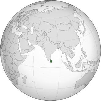
|
Ceylon Britania
|
|||||||||||||
|---|---|---|---|---|---|---|---|---|---|---|---|---|---|
| 1796–1948 | |||||||||||||

|
|||||||||||||

Peta Ceylon Britania tahun 1914
|
|||||||||||||
| Status | Koloni Britania | ||||||||||||
| Ibu kota | Colombo | ||||||||||||
| Bahasa yang umum digunakan | |||||||||||||
| Pemerintahan | Monarki | ||||||||||||
| Penguasa Monarki | |||||||||||||
|
• 1796–1820
|
George III (pertama) | ||||||||||||
|
• 1820 – 1830
|
George IV | ||||||||||||
|
• 1830 – 1837
|
William IV | ||||||||||||
|
• 1837 – 1901
|
Victoria | ||||||||||||
|
• 1901 - 1910
|
Edward VII | ||||||||||||
|
• 1910 – 1936
|
George V | ||||||||||||
|
• Januari – Desember 1936
|
Edward VIII | ||||||||||||
|
• 1936 - 1948
|
George VI (terakhir) | ||||||||||||
| Gubernur | |||||||||||||
|
• 1798–1805
|
(pertama) | ||||||||||||
|
• 1944–1948
|
(terakhir) | ||||||||||||
| Perdana Menteri | |||||||||||||
|
• 1947–1948
|
Don Stephen Senanayake | ||||||||||||
| Legislatif |
|
||||||||||||
| Era Sejarah | Periode Ceylon di bawah kekuasaan Britania | ||||||||||||
| 5 Maret 1796 | |||||||||||||
|
• Pembentukan Administrasi Ganda
|
1798 | ||||||||||||
| 25 Maret 1802 | |||||||||||||
|
•
|
2 Maret 1815 | ||||||||||||
| 4 Februari 1948 | |||||||||||||
| Luas | |||||||||||||
| 1881 | 65.610 km 2 (25.330 sq mi) | ||||||||||||
| 1891 | 65.610 km 2 (25.330 sq mi) | ||||||||||||
| 1901 | 65.610 km 2 (25.330 sq mi) | ||||||||||||
| 1924 | 65.992 km 2 (25.480 sq mi) | ||||||||||||
| 1946 | 65.610 km 2 (25.330 sq mi) | ||||||||||||
| Populasi | |||||||||||||
|
• 1881
|
2,759,700 | ||||||||||||
|
• 1891
|
3,007,800 | ||||||||||||
|
• 1901
|
3,565,900 | ||||||||||||
|
• 1924
|
4,574,550 | ||||||||||||
|
• 1946
|
6,657,300 | ||||||||||||
| Mata uang |
|
||||||||||||
|
|||||||||||||
| Sekarang bagian dari |
|
||||||||||||
|
Source for 1924 area and population:
[
1
]
|
|||||||||||||
Ceylon Britania ( Inggris : British Ceylon ; Sinhala : බ්රිතාන්ය ලංකාව , Brithānya Laṃkāva ; Tamil : பிரித்தானிய இலங்கை, Birithaniya Ilangai ) adalah sebuah koloni mahkota Britania dari tahun 1815 hingga 1948. Awalnya, wilayah tersebut tidak meliputi Kerajaan Kandy , yang menjadi protektorat dari 1815, tetapi dari 1817 sampai 1948, kekuasaan Inggris meliputi seluruh pulau Ceylon, sekarang negara Sri Lanka .
Bacaan lebih lanjut
- Arsecularatne, S. N, Sinhalese immigrants in Malaysia & Singapore, 1860–1990: History through recollections , Colombo, KVG de Silva & Sons, 1991
- Mills, Lennox A. (1933). Ceylon Under British Rule, 1795–1932 . Oxford U.P.
- Malalgoda, Kitsiri (1976). Buddhism in Sinhalese Society, 1750–1900: A Study of Religious Revival and Change . U. of California Press. Diarsipkan dari versi asli tanggal 2016-03-04 . Diakses tanggal 2018-06-03 .
- Peebles, Patrick (2006). The History of Sri Lanka . Greenwood.
- Peebles, Patrick (2001). The Plantation Tamils of Ceylon . Continuum International.
- Schrikker. Alicia (2007). Dutch and British Colonial Intervention in Sri Lanka, 1780–1815: Expansion and Reform . Leiden: Brill.
- Spencer, Jonathan (1990). Sri Lanka: History and the Roots of Conflict . Psychology Press.
- Silva, K.M. de. History of Sri Lanka (1982). pp. 239–488 complete text online free Diarsipkan 2016-03-03 di Wayback Machine .
- Sivasundaram, Sujit (2010). "Ethnicity, Indigeneity, and Migration in the Advent of British Rule to Sri Lanka". The American Historical Review . 115 (2): 428–52. doi : 10.1086/ahr.115.2.428 .
- Sivasundaram, Sujit (2007). "Tales of the Land: British Geography and Kandyan Resistance in Sri Lanka, c. 1803-1850". . Cambridge University Press . 41 (5): 925–65. doi : 10.1017/S0026749X06002642 . ISSN 1469-8099 . JSTOR 4499807 – via JSTOR . (Perlu mendaftar ( help )) .
- Wenzlhuemer, Roland (2008). From Coffee to Tea Cultivation in Ceylon, 1880–1900: An Economic and Social History . Leiden: Brill.
- Wenzlhuemer, Roland. "Indian Labour Immigration and British Labour Policy in Nineteenth‐Century Ceylon," Modern Asian Studies (2007) 41:575–602
- Wickramasinghe, Nira (2006). Sri Lanka in the Modern Age: A History of Contested Indentities . University of Hawaii Press.
Pranala luar
- තුඩපත් මඟින් හෙළිවන සිංහල උරුමය Diarsipkan 2019-08-16 di Wayback Machine .
6°55′00″N 79°50′00″E / 6.9167°N 79.8333°E
- ^ "The British Empire in 1924" . The British Empire . Diakses tanggal 7 November 2017 .


